GNSS World of China

2023 Vol. 48, No. 2

2023, 48(2): 1-2.
Abstract:
Reviews
Discussion on data processing technology about precise time transfer based on GNSS carrier phase observation
TU Rui, ZHANG Pengfei, ZHANG Rui, FAN Lihong, HAN Junqiang, WANG Siyao, LU Xiaochun
2023, 48(2): 1-9. doi: 10.12265/j.gnss.2023003
Abstract:
Precise time transfer is one of the most fundamental works in the field of time frequency. GNSS has become an important means of precise time transfer due to its advantages. In particular, the time transfer technology based on high-precision carrier phase observations developed in recent years has become a research hotspot in the GNSS based time-frequency field. This study comprehensively summarizes the research on GNSS carrier phase precise time transfer, expatiates on the observation model and ambiguity resolution method, and discusses the key technical issues such as precision, consistency, robustness, continuity, real-time, and integrity which are involved in the data processing. It is pointed out that this field should focus on the unity of un-differenced and differenced processing models, the unity of time service by integrating different mechanisms, and the seamless time service of sky, earth, sea and underground.
Review of GNSS direct position estimation techniques
ZHOU Zhijian, RAN Chengxin, DAI Zhiqiang, CHEN Zhengkun, XU Yiyu, ZHU Xiangwei
2023, 48(2): 10-21. doi: 10.12265/j.gnss.2022199
Abstract:
The direct position estimation (DPE) technology is robust to weak signals and multipath interference, which can overcome the shortcomings of traditional two-step methods that can not work normally in complex environments such as cities with tall buildings and indoors. This paper summarizes and analyzes the research status of the direct position estimation technology from three aspects: theory, implementation and application. According to previous researches, the problems of huge amount of computation, low positioning accuracy, and the need for initialization are summed up in the realization of direct position estimation. A receiver design framework in complex environments is presented in the application layer. The receiver judges whether to use DPE for navigation and positioning according to the signal availability, which can improve the positioning performance of the receiver in complex environments with minimal computational resources.
Theory and Discussion
Real-time orbit determination of Beidou satellite based on square root information filtering
YAO Xia, ZHENG Hongjie, YUAN Yongqiang
2023, 48(2): 22-29. doi: 10.12265/j.gnss.2023031
Abstract:
Continuous, stable and high-precision real-time satellite orbit products are essential for the international, scale and intelligent application of the BeiDou system. Current BDS real-time precise orbit products, which rely on “batch processing solution + orbit prediction”, suffer from poor continuity, low stability and low accuracy. Therefore, we introduce the square root information filtering method to perform real-time epoch-by-epoch solutions for the precise orbit of BeiDou satellites. Experimental results demonstrate that the BDS orbits generated by real-time filtering method outperform the ultra-rapid orbit products by effectively avoiding boundary jumps, improving continuity and stability. Moreover, the real-time filtering precise orbit determination method can significantly improve the orbit accuracy of BeiDou satellites, reducing the 3D orbit errors of MEO and IGSO satellites by 46% and 68%, respectively. Also, the validation by satellite laser ranging shows that the orbit accuracy of real-time filtering method is generally better than that of the predicted orbit.
Performance analysis of BDS-3 PPP/INS tightly-coupled positioning
SONG Debiao, SUN Fuping, XIAO Kai, KE Ye, SHANG Xiangyong, YU Yuan
2023, 48(2): 30-35. doi: 10.12265/j.gnss.2022196
Abstract:
With the completion of BDS-3 in China, the requirements of high-precision positioning and attitude determination based on BDS-3 is increasingly urgent. This paper derives the BDS-3 precise point positioning(PPP)model with ionosphere-free combination and inertial navigation system(INS)error equation in geocentric fixed coordinate system , and constructs the BDS-3 PPP/INS tight combination filtering model. This paper evaluates the positioning performance of BDS-3 PPP, BDS-3 PPP/INS loose combination model and BDS-3 PPP/INS tight combination model. The results of the experiment show that the position accuracy of BDS-3 PPP/INS loose combination is basically the same as that of BDS-3 PPP, the position accuracy of BDS-3 PPP/INS tight combination model in the east, north and sky directions is 7.9 cm, 9.3 cm and 9.4 cm, which is higher than that of BDS-3 PPP/INS loose combination model by 38.3%, 33.1% and 35.6%; the speed is improved by 27.3%, 45.8% and 12% respectively in three directions; the attitude accuracy of both is equal.
Comparison and analysis of GNSS precision point positioning performance based on DCB and OSB products
LIU Honghui, WANG Qianxin, YU Zhihao, WANG Maolei, LIU Yongliang
2023, 48(2): 36-42. doi: 10.12265/j.gnss.2022191
Abstract:
With the development of the Global Navigation Satellite System (GNSS), the channels and frequencies used for precision point positioning (PPP) are gradually diversified. Therefore, based on the original observation equations, this study derived the dual-frequency ionosphere-free (IF) PPP model for differential code bias (DCB) and observable-specific signal bias (OSB) products, respectively, and used 10-day continuous observation data collected from 50 Multi-GNSS Experiment (MGEX) stations to analyze the performance of the PPP model for each GNSS system. The results show that the performance of PPP model using the OSB product is consistent with that of the conventional DCB product, and the OSB product is more convenient to use and has more applications in future multi-frequency PPP.
Positioning performance analysis of single epoch RTK with Beidou-3 new frequency point (B1C/B2a)
TAO Zhenqiang, CHEN Jian, ZHAO Xingwang, LIU Chao, LIU Chunyang
2023, 48(2): 43-52. doi: 10.12265/j.gnss.2022195
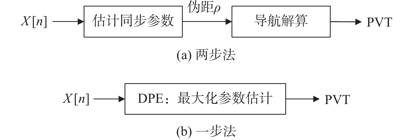
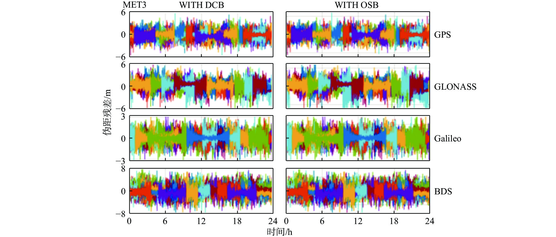
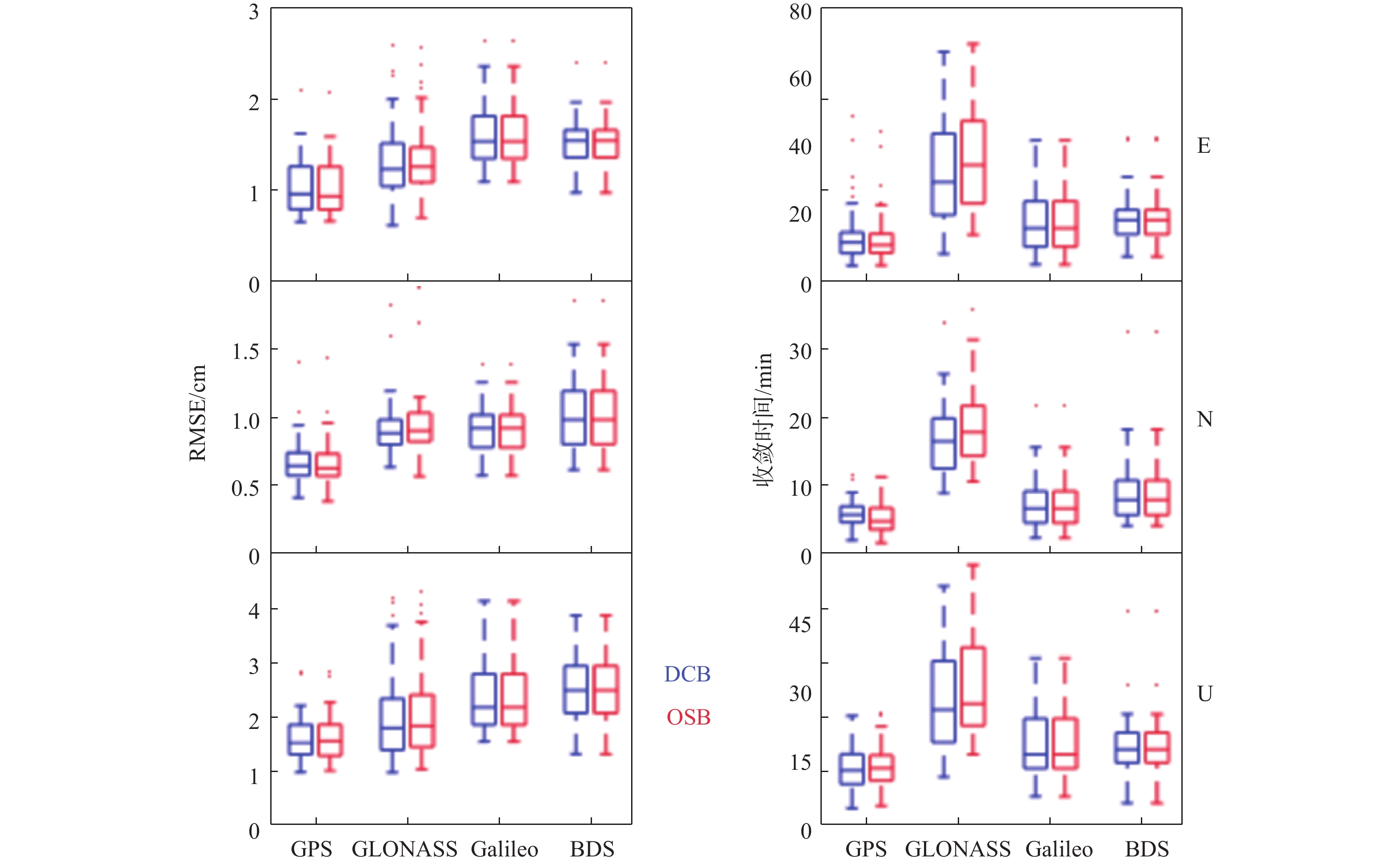
Abstract:
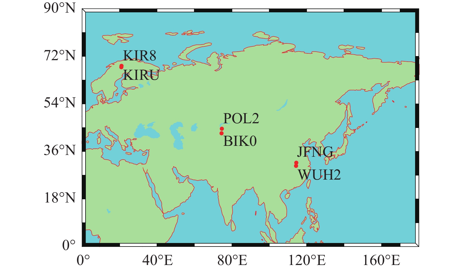
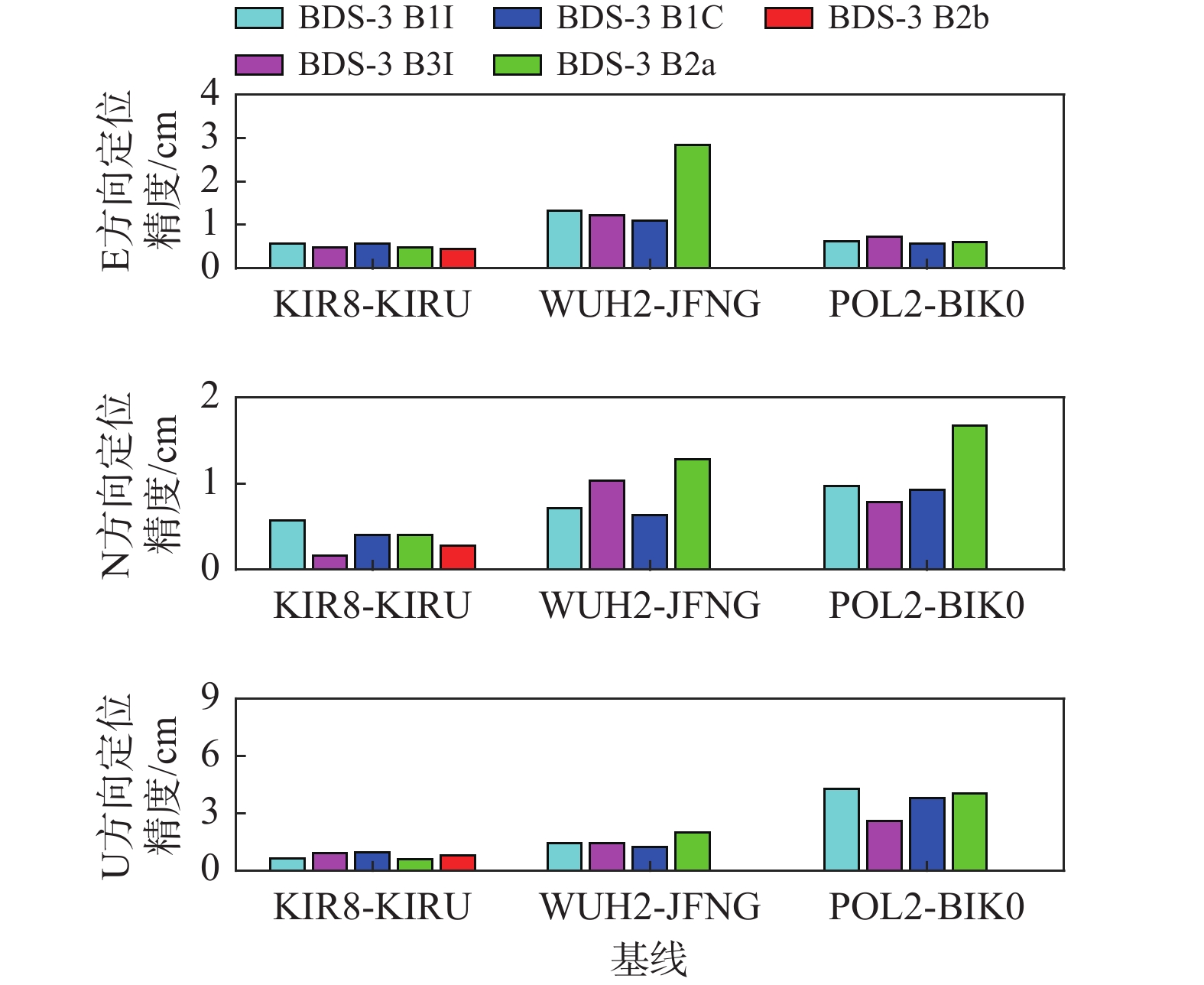
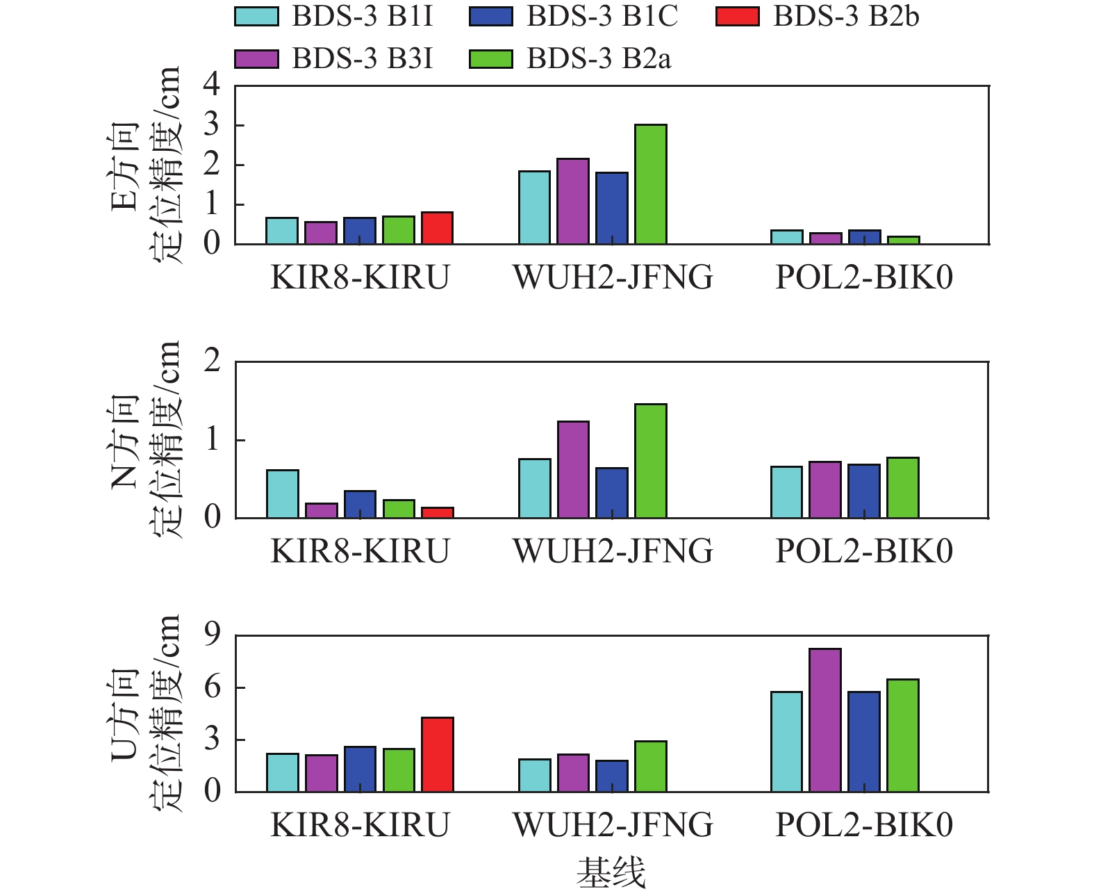
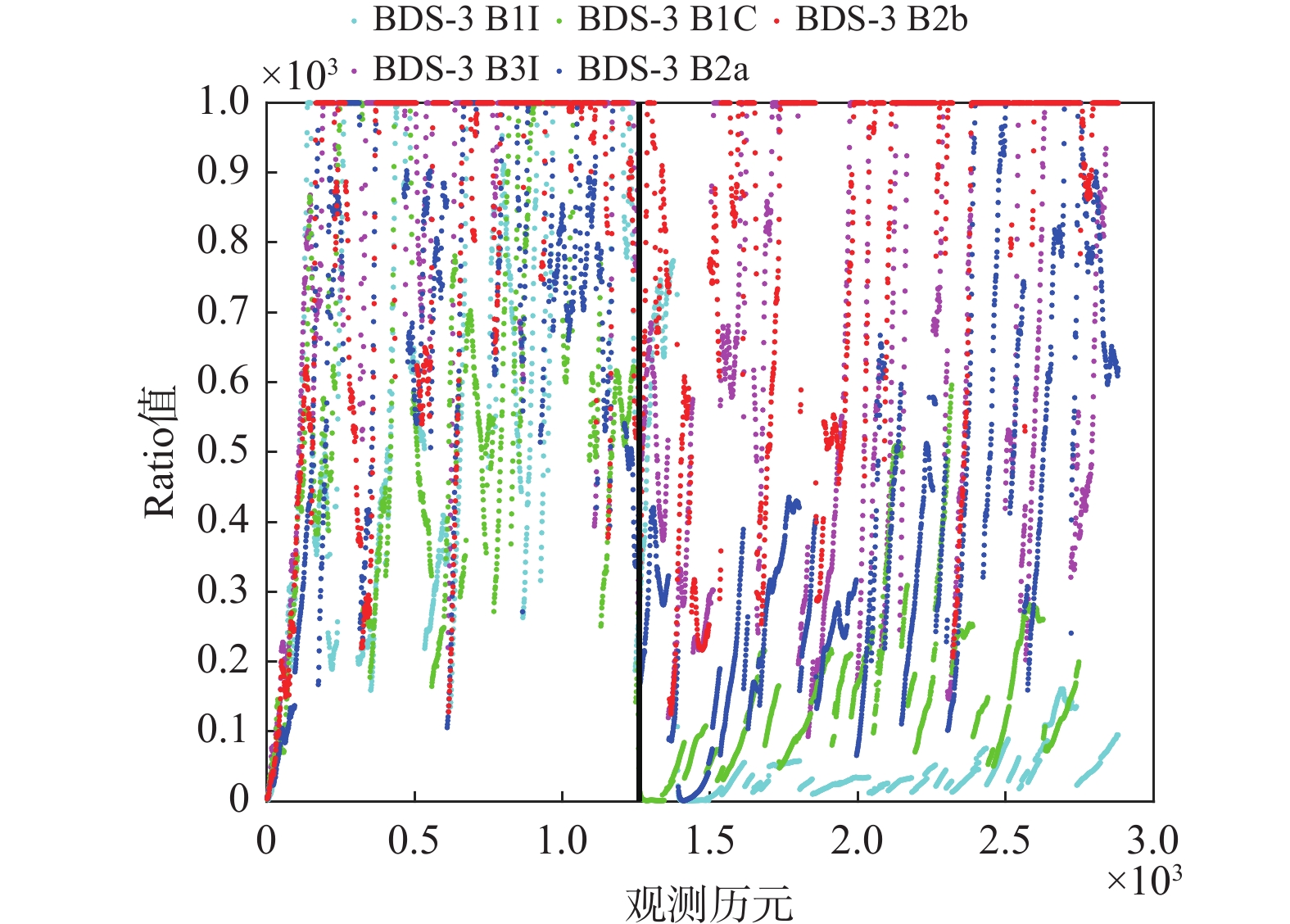
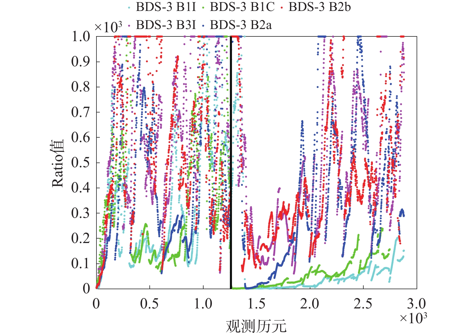
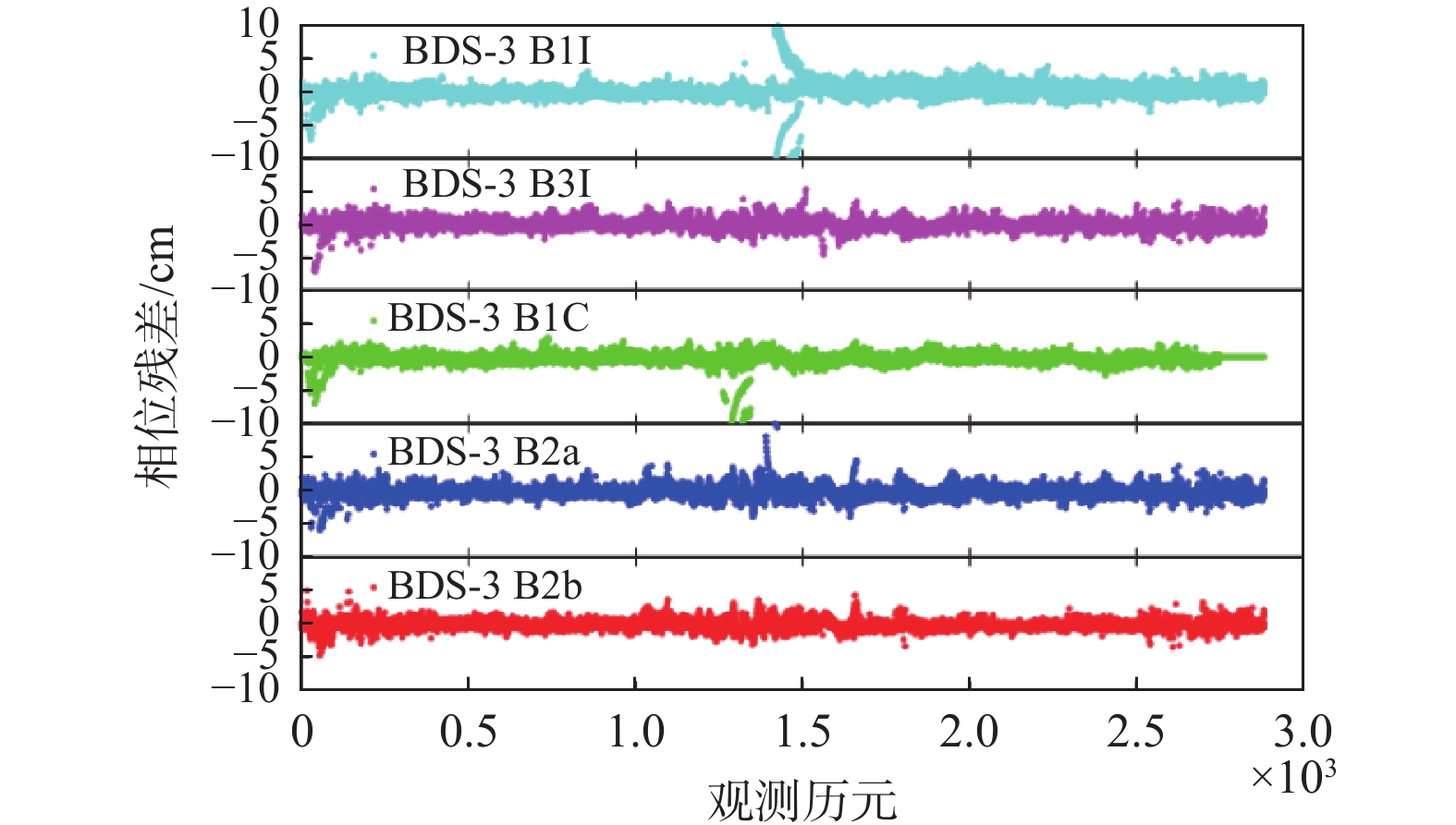
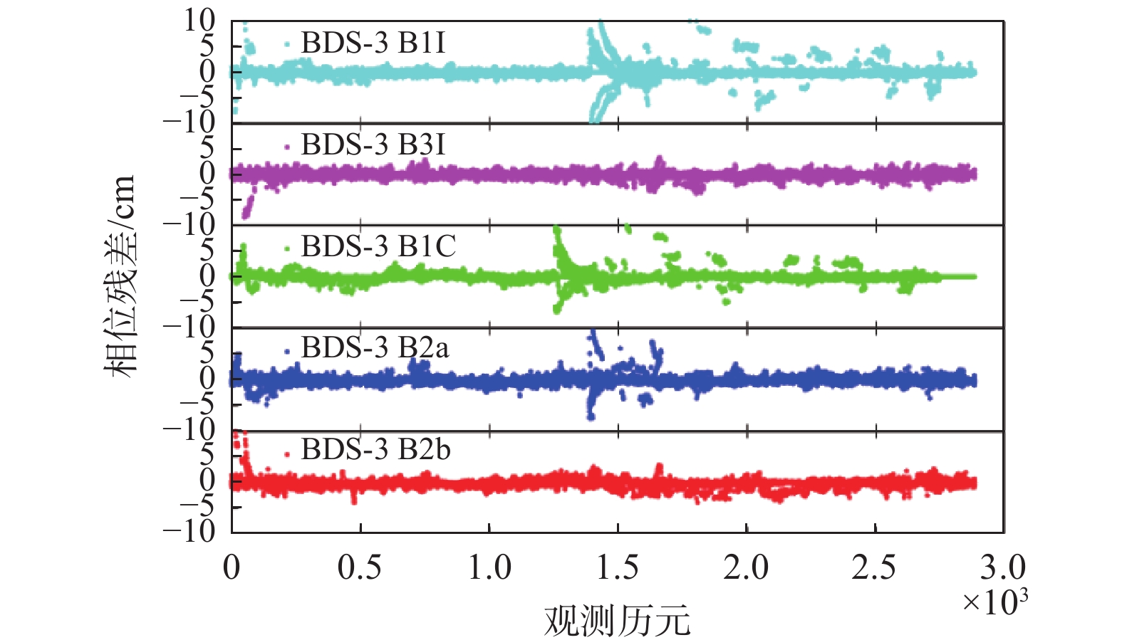
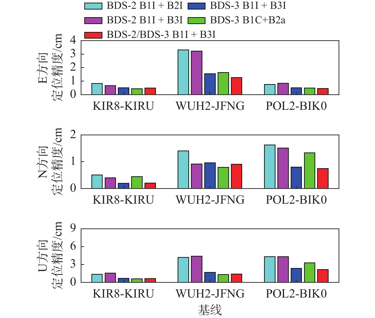
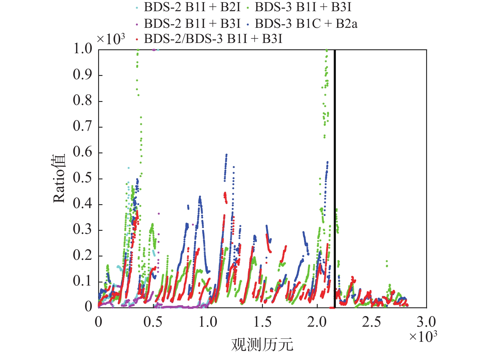
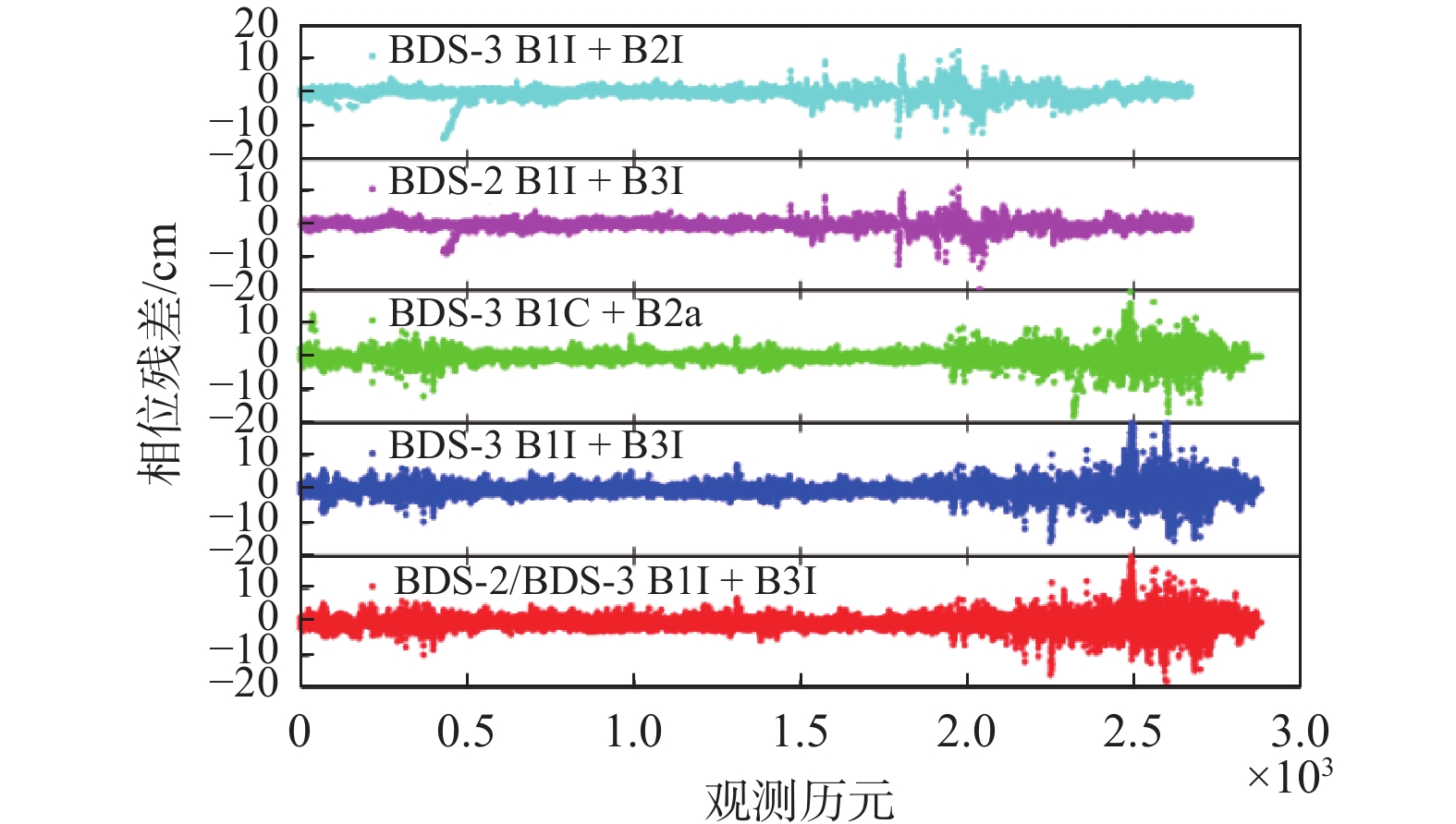
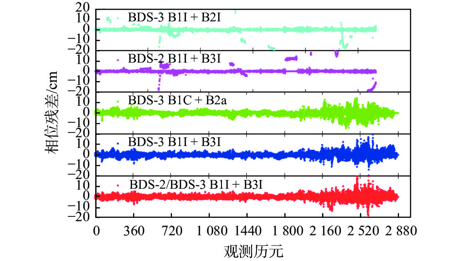
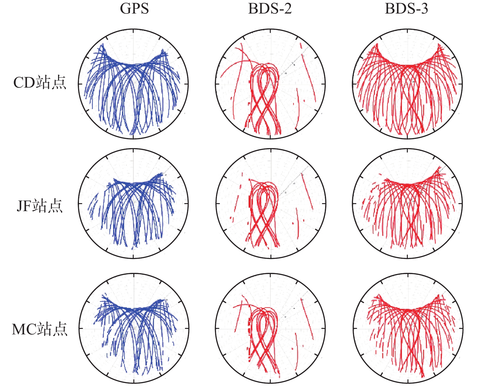
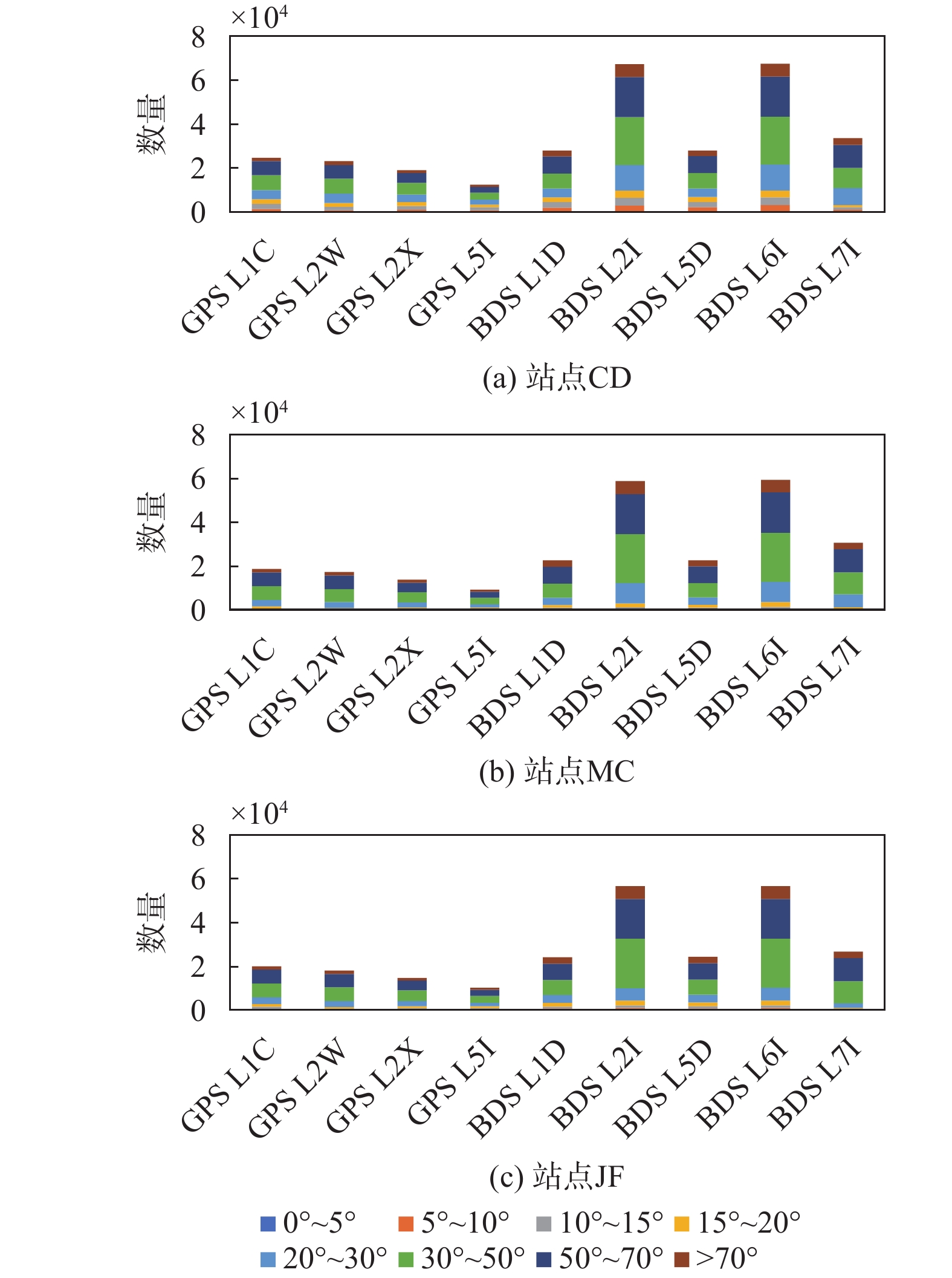
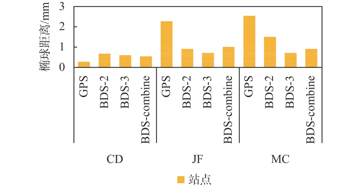
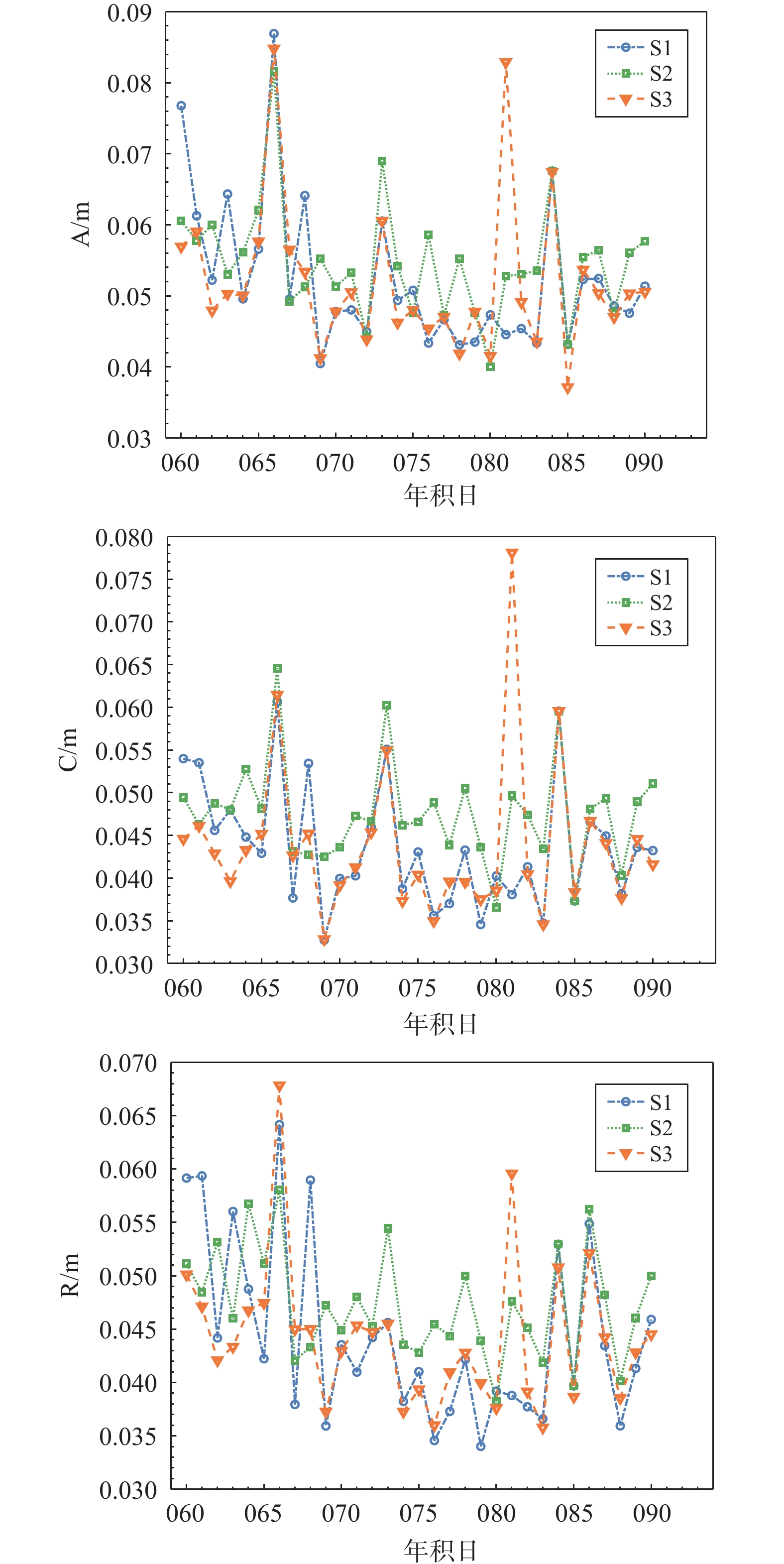
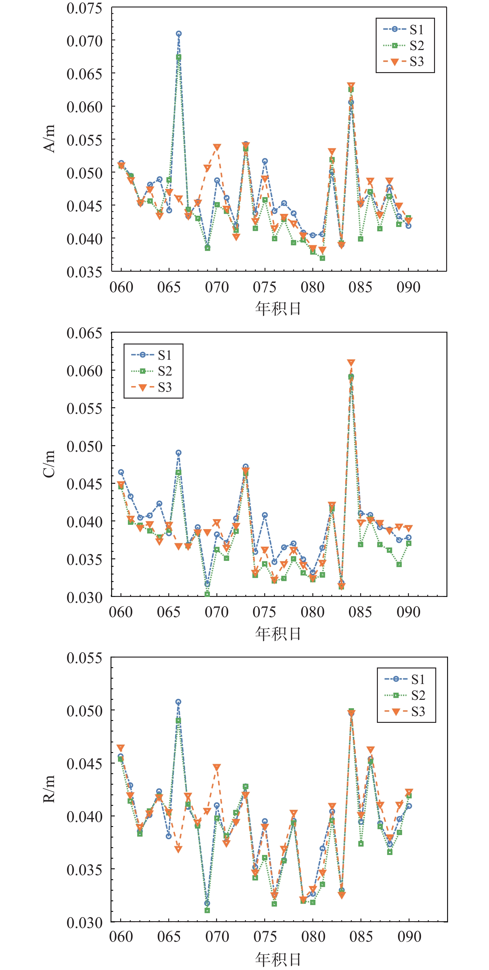
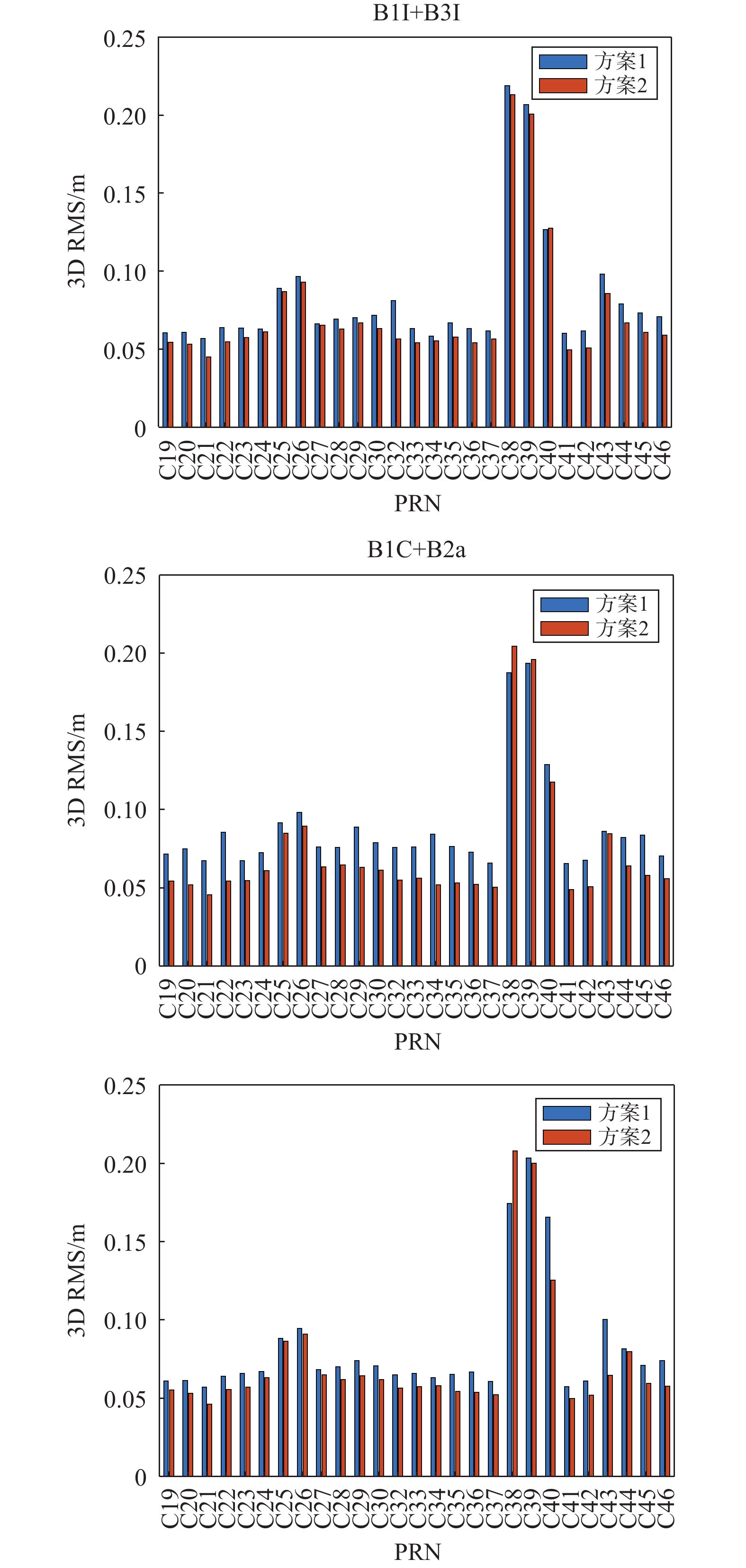
The design of new frequency points (B1C/B2a) for BDS-3 effectively increases the diversity of multi-frequency combination positioning as well as improves the positioning performance of the BDS system. To systematically evaluate the RTK positioning performance of the new frequency point for BDS-3, 6 MGEX tracking stations were selected to form three baselines. Five single-frequency schemes of BDS-3 B1I/B3I/B1C/B2a/B2b, five dual-frequency uncombined schemes of BDS-2 B1I+B2I, BDS-2 B1I+B3I, BDS-3 B1C+B2a, BDS-3 B1I+B3I, BDS-2/BDS-3 B1I+B3I and a five-frequency uncombined scheme of BDS-3 B1I+B3I+B1C+B2a+B2b were designed for real-title kinematic(RTK) solving tests. When the baseline length does not exceed 25 km, the test results show that, in static mode, in east (E), north (N) and up (U) directions, the single-frequency positioning accuracy of BDS-3 new frequency point B1C/B2a is better than 2.85 cm, 1.67 cm and 4.02 cm respectively, and the dual-frequency positioning accuracy is better than 1.63 cm, 1.33 cm and 3.26 cm respectively, and the five-frequency positioning accuracy is better than 2.04 cm, 1.12 cm and 3.17 cm respectively; in kinematic mode, in E, N and U directions, the single-frequency positioning accuracy is better than 3.03 cm, 1.45 cm and 6.49 cm respectively, and the dual-frequency positioning accuracy is better than 1.92 cm, 0.95 cm and 6.71 cm respectively, and the five-frequency positioning accuracy is better than 2.32 cm, 0.91 cm and 4.89 cm respectively. The dual frequency positioning accuracy of BDS-3 new frequency point B1C+B2a and old frequency point B1I+B3I are compared in both modes, and are both better than that of the the BDS-2 B1I+B2I and B1I+B3I dual frequency. In addition, the positioning accuracy and stability of BDS-3 five-frequency uncombined scheme are better than single-frequency and dual-frequency uncombined schemes.
Satellite navigation signal acquisition method based on joint optimization of complexity and performance
ZHANG Pengcheng, HUANG Xinming, HOU Linyuan, LI Jingyuan, OU Gang
2023, 48(2): 53-58. doi: 10.12265/j.gnss.2022169
Abstract:
Aiming at the high computational complexity of short burst signal acquisition, an acquisition method based on the joint optimization of computational complexity and acquisition performance is proposed. The acquisition performance and computational complexity of the segmented correlation-video accumulation acquisition algorithm using parallel frequency search is derivatively analyzed. The joint acquisition optimization factor is constructed, and the optimal design is carried out for different frequency search intervals, different receiver sensitivities, and different numbers of correlators, and the optimal number of segments for computational complexity and acquisition performance is obtained. The simulation results show that this method can effectively control the computational complexity of the acquisition algorithm. When the input carrier-to-noise ratio is 45 dB-Hz, the number of correlators is 8, and the Doppler search interval is 2 000 Hz, meanwhile, the computational complexity can be reduced by 21.2% compared with the traditional acquisition optimization method.
Influence of differential code bias on QZSS single point positioning
LI Jiahao, JIA Xiaolin, DU Yanjun, XU Yu
2023, 48(2): 59-64. doi: 10.12265/j.gnss.2022220
Abstract:
To investigate the effect of differential code bias on Quasi-Zenith Satellite System(QZSS) pseudorange single-point positioning, this paper derives a differential code bias(DCB) and timing group delay(TGD) correction model for QZSS pseudorange single-point positioning, and selects 6 Multi-GNSS Experiment(MGEX) stations for 7 day of continuous observation data to conduct experiments according to two different schemes. The results show that the monthly stability of DCB products is good without obvious fluctuations, and the monthly stability of each satellite is better than 0.2 ns, and the mutual difference value with TGD is better than 2.5 ns. The impact of TGD/DCB correction on SPP accuracy is of meter level, and the horizontal positioning accuracy can be improved from 4–9 m to 3–6 m after TGD/DCB correction, and the elevation direction can be improved from 7–9 m to 5–7 m, and the improvement rate is about 10%–46%, which shows that DCB has a large impact on the single-point positioning accuracy and cannot be ignored in the positioning solution.
Time-differenced Carrier Phase velocity measurement method and accuracy evaluation based on GNSS real-time data stream
HU Bingyan, LYU Huanghui, ZHENG Jiawei, FANG Rongxin
2023, 48(2): 65-70. doi: 10.12265/j.gnss.2023009
Abstract:
In order to meet the real-time and accurate monitoring and early warning of geological disasters, and in view of the fact that the traditional GNSS carrier phase difference speed measurement mainly adopts the post-event simulation real-time processing mode, the post-event GNSS carrier phase difference speed measurement program is improved. Added the function of real-time data stream reception and real-time decoding of the RTCM to meet the needs of real-time speed measurement. Use the static station experiment and the shaking table to simulate the sine wave vibration experiment to evaluate the accuracy of the improved GNSS real-time speed measurement program. The root mean square (RMS) of the error in NEU directions in the static experiment is better than 5 mm/s; the RMS difference between the calculated speed in NEU directions and the true value in the dynamic experiment is 10.4 mm/s. It shows that the speed measurement accuracy of the real-time GNSS speed measurement program in this experiment can reach millimeter level under static real-time speed measurement conditions, and the speed measurement accuracy can still reach centimeter level under real-time dynamic conditions.
Adaptive step detection method combining CNN-BiLSTM-SA motion pattern recognition
YANG Yuncheng, WU Fei, ZHU Hai, ZHU Runzhe, YANG Mingze
2023, 48(2): 71-80. doi: 10.12265/j.gnss.2022167
Abstract:
With the popularity of location based services (LBS), smartphone-based pedestrian step detection methods have important impacts on pedestrian dead reckoning (PDR). We propose an adaptive step detection method combining CNN-BiLSTM-SA motion pattern recognition to address the problem that traditional methods have large step counting errors under multiple pedestrian motion patterns. Firstly, the motion patterns are classified according to the walking characteristics of pedestrians, and the local features of different motion patterns of pedestrians are extracted by using convolutional neural network (CNN), and the weights of the extracted motion features are assigned by using self-attention (SA) mechanism, and then the bidirectional long short term memory (BiLSTM) network is combined to mine the pre-post temporal relationship of pedestrian motion features for classification and recognition. Then the peak detection algorithm with two feature constraints, adaptive minimum peak distance and adaptive dynamic threshold, is proposed to detect the step frequency according to the classification results, and the threshold size is dynamically adjusted in walking. The experimental results show that the average error rate of the proposed method for step frequency detection under eight combined motion patterns is 1.31%, which is 5.97% lower than that of the traditional peak detection, and also better than the fixed threshold method.
Evaluation and analysis of satellite data of the BDS-3 system based on provincial regional ground-based augmentation system
WEI Yikuan, LI Fangting, TANG Xiaofei, ZHAO Peng
2023, 48(2): 81-87. doi: 10.12265/j.gnss.2022203
Abstract:
The quality of navigation satellite observation data is a direct factor that affects the positioning accuracy of ground augmentation system. The number of satellite observations obtained by BeiDou ground-based augmentation system after the adaptive transformation of Beidou-3 Navigation Satellite System (BDS-3) has increased by 30%−50% compared with the original Beidou-2 Navigation Satellite System (BDS-2). It is very important to evaluate and analyze the quality of these observations. In this paper, we propose a method to evaluate the quality of observation values of reference stations, such as analytical data integrity and multipath error, and use two methods such as zero-base line test and precise single point positioning test, to integrate the BDS-3 data analysis method of regional ground augmentation system. Based on this method, an empirical test was conducted in the study area. The results show that the data quality of BDS-3 satellites in the Asia-Pacific region has reached the same level as that of GPS. Due to the better spatial distribution structure of BDS-3 satellites, the available observation value of high elevation angle (altitude angle >50°) obtained by the ground stations has increased more than 200% compared with that of single GPS system.
Wavelet denoising and cycle slip detection and repair of BDS triple-frequency signal
CAI Wei, CHEN Mingjian, ZHOU Shuhan
2023, 48(2): 88-94. doi: 10.12265/j.gnss.2022175
Abstract:
The traditional triple-frequency code-phase combination method is easily affected by the pseudorange observation noise, and it is difficult to detect the insensitive small cycle slip. The triple-frequency geometry-free (GF) phasemethod has the ability to detect sensitive small cycle slip, but it has the problem of ill-conditioned equations. In view of this, this paper proposes a method of combining code-phase combination and GF model using wavelet denoising. Firstly, the pseudorange observations were denoised by wavelet transform. Then, the optimal combination model is constructed by selecting the optimal combination coefficient. Therefore, the quality of source data is ensured by wavelet denoising, and the accuracy of cycle-slip detection and repair is improved by code-phase combination and GF combination. At the same time, the problem of ill-conditioned equations is solved. Finally, the least square method combined with QR decomposition algorithm is used to fix the optimal integer of the cycle slip and repair the cycle slip by using spatial search and 1-norm minimum principle, and the triple-frequency measurement data of the BeiDou Navigation Satellite System (BDS) is collected for experimental verification. The experimental results show that the optimal combination model of wavelet transform denoising can detect and repair all kinds of cycle slips, especially for insensitive small cycle slips.
Automatic acquisition method of BeiDou Satellite Navigation weak signal based on density clustering
LIU Lunyan, ZHOU Yan, TANG Liyi
2023, 48(2): 95-100. doi: 10.12265/j.gnss.2022198
Abstract:
In order to effectively capture BeiDou Satellite Navigation (BDS) weak signal information under the influence of external RF signals and mixed frequency processing noise of navigation receiver, the automatic acquisition method of BDS weak signal based on density clustering is studied. The density clustering is used to design the satellite beam direction from the cluster center of BDS signal source in combination with the cluster center, and constrain the receiving range of satellite navigation signals, and resist the airspace interference of jamming signals. The noise information of navigation signal under the effect of beam anti-jamming is removed by wavelet threshold method. The correlation between the de-noised navigation signal and the known weak signal is calculated using the correlation function modulus calculation method. If the correlation is greater than the threshold value, the de-noised navigation signal is a weak signal. The experiment verifies that under the interference of external RF signals and mixers, this method has the ability to automatically capture the weak signals of BDS.
Precision analysis of BDS-3 multi-frequency undifferenced and uncombined precision orbit determination
JING Xin, LI Jianwen, ZHOU Shuhan, CAI Wei, KE Neng
2023, 48(2): 101-110. doi: 10.12265/j.gnss.2022219
Abstract:
In view of the observation data of BDS-3 at 5 frequencies and the theory of un-differenced and un-combined (UDUC) precise orbit determination, this paper introduces the UDUC model and parameter estimation method, proposes the strategy of station selection using the K-means algorithm, and analyzes the advantages of UDUC method. Through two kinds of station selection schemes, manual experience selection and K-means, 3 frequency selection methods of BDS-3 5-frequency, B1C+B2a, B1I+B3I are used respectively, and 30 IGS observation stations are used to carry out precise orbit determination for BDS-3 MEO and IGSO satellites. The experimental results show that when the stations which can receive B1C+B2a frequency observation data are insufficient, the UDUC method can increase the number of observation data and optimize the station layout by using the 5-frequency observation data so that the orbit determination accuracy can be improved. Compared with B1C+B2a, the monthly average RMS of 5-frequency in A, C and R directions increase by 0.003 m, 0.004 m, 0.003 m respectively, and that of 3D RMS increases by about 0.007 m. The stations selected through the K-means algorithm are more reasonably distributed and have higher orbit determination accuracy than manual experience selection scheme. With the 3 frequency selection methods, the monthly average RMS of MEO satellites in A, C and R directions are improved by 0.009 m, 0.017 m, 0.009 m respectively.
Technical Report and Application
Analysis of atmospheric error correction in satellite-ground time comparison and its influencing factors
WANG Rong, BAI Yan, ZHAO Jiaqi, GUO Yanming, CHEN Xiaofeng
2023, 48(2): 111-119. doi: 10.12265/j.gnss.2022187
Abstract:
Due to the complex space environment, the influence of the atmosphere on the radio and microwave signals is one of the main error sources for the high-precision satellite-to-earth two-way time matching. In order to meet the requirements of the satellite-ground time comparison, the ionospheric error correction method and dispersive troposphere delays correction method in the triple-frequency system are studied, the main factors affecting the atmospheric error correction are discussed, and the atmospheric error correction and the satellite-ground time comparison results under different scenarios are simulated and analyzed. The simulation results show that when the satellite attitude error is controlled within 100 as, the phase center calibration error is controlled within 5 mm, and the orbit position error is controlled within 30 cm.The root mean square (RMS) of ionospheric and tropospheric error residual are less than 0.006 ps and 0.06 ps respectively after correction, and the accuracy of star-ground time comparison is better than ps level.
BDS navigation satellite clock difference prediction based on PSO-Elman neural network
WANG Jingli, TONG Xiaoyu, ZHANG Mei
2023, 48(2): 120-126. doi: 10.12265/j.gnss.2022183
Abstract:
Satellite clock error is one of the important factors affecting the positioning accuracy of navigation and positioning system. Aiming at the problem of optimizing the precision clock error prediction performance of the BeiDou Navigation Satellite System (BDS), a method of optimizing the Elman neural network clock error prediction model based on particle swarm optimization (PSO) is proposed to solve the influence of the local optimal problem of Elman neural network on the clock error prediction results. Firstly, the clock error product is preprocessed. The initial weights and thresholds of Elman neural network are determined by iterative optimization of PSO algorithm, and the preprocessed sequence data are used for training modeling. The BDS precision clock error product data provided by IGS Data Analysis Center (WHU) of Wuhan University are used to predict the clock error, and then the prediction results are restored to predict the clock error. The results show that compared with the quadratic polynomial (QP) model, the polynomial (SA) model with additional period term, and the grey (GM) model, the accuracy is improved by 90.7%, 84.2%, 81.6%, and the stability is improved by 85.3%, 76.3%, 36.1%, respectively. The experimental results show that the prediction accuracy and stability of PSO-Elman model are significantly improved in 1−12 h short term forecast simulation, which verifies the feasibility of the proposed method.