

Research progress of GNSS atmosphere-ocean remote sensing technology
-
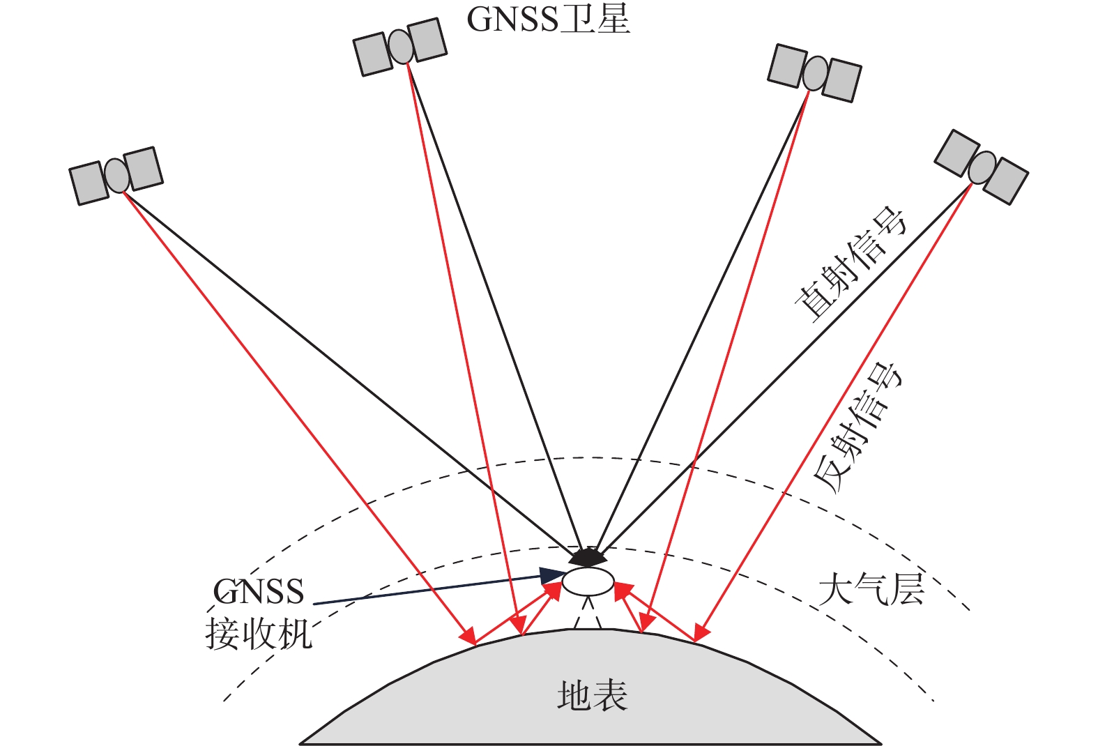
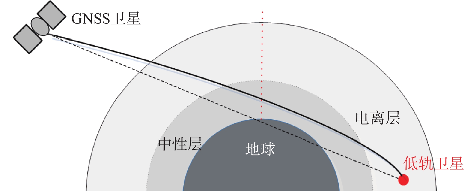
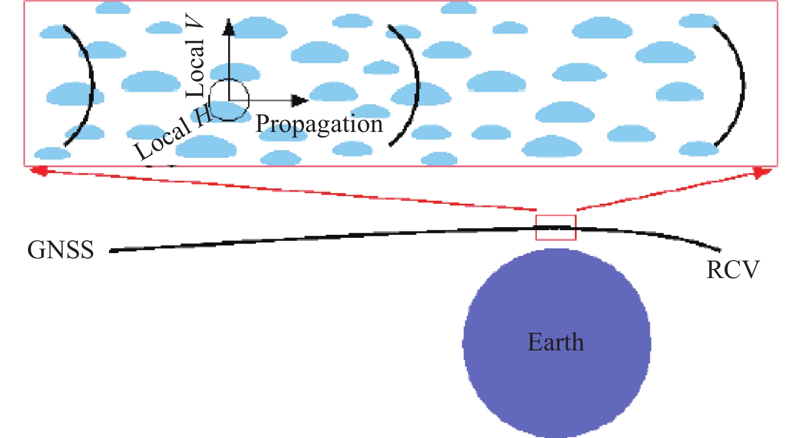
摘要: 全球卫星导航系统(GNSS)信号资源的大气海洋遥感技术一直是一个研究热点. 伴随着GNSS系统的建设和发展,相继出现了利用GNSS延迟信号、反射信号、掩星信号、极化信号获取大气和海洋环境参数的一系列新技术新方法. 在回顾GNSS大气海洋遥感技术概况的基础上,先后概述了GNSS延迟信号(GNSS-D)技术、GNSS反射测量(GNSS-R)技术、GNSS无线电掩星(GNSS-RO)技术、GNSS极化掩星(GNSS-PRO)技术的基本原理,比较全面系统地分析了其国内外研究和应用方面的现状及最新进展,特别是新兴GNSS-PRO技术的机理、优势及发展现状. 最后对该研究领域的发展前景进行了一些探讨,相关技术的突破和发展必将在气象、水文、海洋、陆地、空间环境等地球科学领域发挥越来越重要的作用.
-
关键词:
- 全球卫星导航系统(GNSS) /
- 遥感 /
- 北斗信号 /
- GNSS极化掩星(GNSS-PRO) /
- 极化相移
Abstract: The atmosphere-ocean remote sensing technology of fully mining Global Navigation Satellite Systems (GNSS) signal resources has always been a research hotspot. With the construction and development of GNSS, a series of novel technologies and methods to obtain the parameters of atmospheric and oceanic environment by GNSS delayed signals, reflected signals, occultation signals and polarimetric signals have appeared successively. In this paper, the principles of GNSS delay (GNSS-D), GNSS reflectometry (GNSS-R), GNSS radio-occultation (GNSS-RO) and GNSS Polarimetric radio-occultation (GNSS-PRO) technologies are respectively summarized on the basis of reviewing the general situation of GNSS atmosphere-ocean remote sensing technology. The progress of their research are also illustrated comprehensively and systematically, especially the mechanism, advantages and status of emerging GNSS-PRO technology. Finally, the development prospect of this field is discussed. The breakthrough and development of related technologies will play an increasingly important role in the earth science fields such as meteorology, hydrology, ocean, land and space environment. -
[1] 李国平. 地基GPS气象学[M]. 北京: 科学出版社, 2010. [2] JIN S G, CARDELLACH E, XIE F Q. GNSS remote sensing: theory, methods and applications [M]. Springer, Germany, 2014: 17-240. [3] 张京江, 楚艳丽. 滑动时间窗技术在地基GPS数据实时解算中的应用[J]. 气象科技, 2014, 42(2): 204-207. DOI: 10.3969/j.issn.1671-6345.2014.02.004 [4] CARDELLACH E, RIUS A, CEREZO F. Polarimetric GNSS radio-occultations for heavy rain detection[C]// IEEE International Geoscience and Remote Sensing Symposium, 2010: 3841-3844. DOI: 10.1109/IGARSS.2010.5650907 [5] 郭志梅, 李黄, 缪启龙. GPS探测气象参数的技术进展[J]. 气候与环境研究, 2008, 13(2): 212-224. [6] BEVIS M, BUSINGER S, CHISWELL S, et al. GPS meteorology: mapping zenith wet delays onto precipitable water[J]. Journal of applied meteorology, 1994, 33(3): 379-386. DOI: 10.1175/1520-0450(1994)033<0379:GMMZWD>2.0.CO;2 [7] DUAN J P, BEVIS M, FANG P, et al. GPS meteorology: direct estimation of the absolute value of precipitable water vapor[J]. Journal of application meteorology, 1996, 35(6): 830-838. DOI: 10.1175/1520-0450(1996)035<0830:GMDEOT>2.0.CO;2 [8] TREGONING P, BOERS R, O'BRIEN D, et al. Accuracy of absolute precipitable water vapor estimates from GPS observations[J]. Journal of geophysical research atmospheres, 1998, 103(D22): 28701-28710. DOI: 10.1029/98jd02516 [9] BRAUN J J, ROCKEN C, LILJEGREN J C. Comparisons of line-of-sight water vapor observations using the Global Positioning System and a pointing microwave radiometer[J]. Journal of atmospheric and oceanic technology, 2003, 20(5): 606-612. DOI: 10.1175/1520-0426(2003)202.0.CO [10] CHAMPOLLIONA C, MASSONA F, BOUIN N N, et al. GPS water vapor tomography: preliminary results from the ESXOMPTE field experiment[J]. Atmospheric research, 2005, 74(1): 253-274. DOI: 10.1016/j.atmosres.2004.04.003 [11] PERLER D, GEIGER A, HURTER F. 4D GPS water vapor tomography: new parameterized approaches[J]. Journal of geodesy, 2011, 85(8): 539-550. DOI: 10.1007/s00190-011-0454-2 [12] 毛节泰. GPS的气象应用[J]. 气象科技, 1993(4): 45-49. [13] 李成才, 夏青. 全球定位系统遥感水汽总量[J]. 科学通报, 1999, 44(3): 333-336. DOI: 10.3321/j.issn:0023-074X.1999.03.024 [14] 郭志梅. 利用地基GPS资料反演大气可降水量的初步研究[D]. 南京: 南京信息工程大学, 2005. [15] 宋淑丽. 地基GPS网对水汽三维分布的监测及其在气象学中的应用[D]. 上海: 中国科学院上海天文台, 2004. [16] 毕研盟, 杨光林, 聂晶. 基于Kalman滤波的GPS水汽层析方法及其应用[J]. 高原气象, 2011, 30(1): 109-114. [17] 吴旭祥, 郭秋英, 侯建辉. 基于BDS精密星历产品的水汽探测性能分析[J]. 全球定位系统, 2019, 44(5): 91-99. [18] 郭秋英, 侯建辉, 刘传友, 等. 基于北斗三号的大气水汽探测性能初步分析[J]. 全球定位系统, 2021, 46(1): 89-97,11. DOI: 10.12265/j.gnss.2020090802 [19] LANYI G E, ROTH T. A comparison of mapped and measured total ionospheric electron content using global positioning system and beacon satellite observations[J]. Radio science, 1988, 23(4): 483-492. DOI: 10.1029/RS023i004p00483 [20] MANNUCCI A J, WILSON B D, EDWARDS C D. A new method for monitoring the earth’s ionospheric total electron content using the GPS global network[J]. Proceedings institute of navigation, 1993: 1323-1332. DOI: 10.2307/1324176 [21] HERNÁNDEZ-PAJARES M. IGS ionosphere WG status report: performance of IGS ionosphere TEC maps position paper[J/OL]. [2021-09-30]. Pajares, 2004. https://www.researchgate.net/publication/237789274_Performance_of_IGS_Ionosphere_TEC_Maps. [22] YUAN Y B, HUO X L, OU J K, et al. Refining the Klobuchar ionospheric coefficients based on GPS observations[J]. IEEE transactions on aerospace and electronic systems, 2008, 44(4): 1498-1510. DOI: 10.1109/TAES.2008.4667725 [23] KUNITSYN V E, ANDIREEVA E S, RAZINKOV O G. Possibilities of the near-space environment radio tomography[J]. Radio science, 1997, 32(5): 1953-1963. DOI: 10.1029/97RS00837 [24] HOWE B M, RUNCIMAN K, SECAN J A. Tomography of the ionosphere: four-dimensional simulations[J]. Radio science, 1998, 33(1): 109-128. DOI: 10.1029/97RS02615 [25] 盛传贞, 张京奎, 张宝成. 不同全球电离层格网产品在中国区域的应用精度评估与分析[J]. 全球定位系统, 2021, 46(4): 8-15. DOI: 10.12265/j.gnss.2021012703 [26] 刘经南. 广域差分GPS原理和方法[M]. 北京: 测绘出版社, 1999. [27] 张小红, 李征航, 蔡昌盛. 用双频GPS观测值建立小区域电离层延迟模型研究[J]. 武汉大学学报(信息科学版), 2001, 26(2): 140-143,159. [28] 柳景斌, 王泽民, 王海军, 等. 利用球冠谐分析方法和GPS数据建立中国区域电离层TEC模型[J]. 武汉大学学报(信息科学版), 2008, 33(8): 792-795,814. [29] 任晓东. 多系统GNSS电离层TEC高精度建模及差分码偏差精确估计[D]. 武汉: 武汉大学, 2017. [30] 徐继生, 邹玉华. 时变三维电离层层析成像重建公式[J]. 地球物理学报, 2003, 46(4): 438-445. DOI: 10.3321/j.issn:0001-5733.2003.04.002 [31] 吴寒, 姚宜斌, 陈鹏, 等. GNSS电离层层析成像算法研究[J/OL]. 武汉大学学报(信息科学版), 2013, 38(12): 1405-1408. [32] 霍星亮, 袁运斌, 欧吉坤, 等. 顾及电离层变化的层析反演新算法[J]. 地球物理学报, 2016, 59(7): 2393-2401. DOI: 10.6038/cjg20160706 [33] MARTIN-NEIRA M. A passive reflectometry and interferometry system (PARIS): application to ocean altimetry[J/OL]. [2021-09-30]. ESA journal, 1993, 17(4): 331-355. https://www.researchgate.net/publication/279897829_A_Passive_Reflectometry_and_Interferometry_System_PARIS_Application_to_ocean_altimetry [34] LIN B, KATZBERG S J, GARRISON J L, et al. Relationship between GPS signals reflected from sea surfaces and surface winds: modeling results and comparisons with aircraft measurements[J]. Journal of geophysical research, 1999, 104(C9): 20713-20727. DOI: 10.1029/1999JC900176 [35] 周晓中. GNSS-R海洋遥感原理与方法研究[D]. 南京: 解放军理工大学, 2010. [36] ZAVOROTNY Z U, VORONOVICH A G, KATZBERG S J, et al. Extraction of sea state and wind speed from reflected GPS signals: modeling and aircraft measurements [C]//Geoscience and Remote Sensing Symposium, 2000: 1507-1509. DOI: 10.1109/IGARSS.2000.857255 [37] GARRISON J L, KOMJATHY A, ZAVOROTNY V U, et al. Wind speed measurement using forward scattered GPS signals[J]. IEEE transactions on geoscience and remote sensing, 2002, 40(1): 50-65. DOI: 10.1109/36.981349 [38] CARDELLACH E, RUFFINI G, PINO D, et al. Mediterranean balloon experiment: ocean wind speed sensing from the stratosphere, using GPS reflections[J]. Remote sensing of environment, 2003, 3(88): 351-362. DOI: 10.1016/S0034-4257(03)00176-7 [39] FOTI G, GOMMENGINGER C, JALES P, et al. Spaceborne GNSS reflectometry for ocean winds: first results from the UK TechDemoSat-1 mission[J]. Geophysical research letters, 2015, 42(13): 5435-5441. DOI: 10.1002/2015GL064204 [40] ZAVOROTNY V U, ZUFFADA C. Assessing the possibility of measuring the thickness of undeformed first-year Arctic sea ice from bistatic reflections of GPS signals[C]//The 2003 Workshop on Oceanography with GNSS-R, 2003. [41] KAINULAINEN J, RAUTIAINEN K, LEMMETYINEN J, et al. Detection of a sea surface salinity gradient using data sets of airborne synthetic aperture radiometer HUT-2-D and a GNSS-R instrument[J]. IEEE transactions on geoscience and remote sensing, 2011, 49(11): 4561-4571. DOI: 10.1109/TGRS.2011.2151864 [42] CHEW C, REAGER J T, SMALL E. CYGNSS data map flood inundation during the 2017 Atlantic hurricane season[J]. Scientific reports, 2018, 8(1): 9336. DOI: 10.1038/s41598-018-27673-x [43] WICKERT J, CARDELLACH E, MARTIN-NEIRA M, et al. GEROS-ISS: GNSS reflectometry, radio occultation, and scatterometry onboard the international space station[J]. IEEE journal of selected topics in applied earth observations and remote sensing, 2016, 9(10): 4552-4581. DOI: 10.1109/JSTARS.2016.2614428 [44] 杨东凯, 张益强, 张其善, 等. 基于GPS卫星信号的海面风场遥感方法研究与实现[J]. 遥感信息, 2006(3): 10-12,18. DOI: 10.3969/j.issn.1000-3177.2006.03.004 [45] 符养, 周兆明. GNSS-R海洋遥感方法研究[J]. 武汉大学学报(信息科学版), 2006, 31(2): 128-131. [46] 王迎强, 严卫, 符养, 等. 利用机载 GNSS反射信号反演海面风速的研究[J]. 海洋学报, 2008, 30(6): 51-59. [47] 王鑫, 孙强, 张训械, 等. 中国首次岸基GNSS-R海洋遥感实验[J]. 科学通报, 2008, 53(5): 589-592. DOI: 10.3321/j.issn:0023-074X.2008.05.015 [48] 万玮, 陈秀万, 彭学峰, 等. GNSS遥感研究与应用进展和展望[J]. 遥感学报, 2016, 20(5): 858-874. [49] 刘原华, 何孟然, 牛新亮. GNSS-R海面风速反演技术研究[J]. 全球定位系统, 2020, 45(2): 55-59. [50] 胡媛, 钟李程, 陈行杨, 等. GNSS-R信噪比信号在海面测高技术的研究综述[J]. 全球定位系统, 2021, 46(4): 1-7. DOI: 10.12265/j.gnss.2021011502 [51] 杨明华, 曹云昌. 基于GNSS-R的后续海冰观测实验[J]. 全球定位系统, 2014, 39(4): 51-54,68. [52] 高洪兴, 杨东凯, 张波, 等. 基于 GNSS 卫星反射信号的海冰厚度探测[J]. 电子与信息学报, 2017, 39(5): 1096-1100. [53] 杨东凯, 王强, 曹云昌, 等. 基于北斗反射信号的海面有效波高探测[J]. 高科技与产业化, 2014(10): 81-83. [54] JIN S G, QIAN X D, WU X R. Sea level change from BeiDou Navigation Satellite System-reflectometry (BDS-R): first results and evaluation[J]. Global and planetary change, 2017(149): 20-25. DOI: 10.1016/j.gloplacha.2016.12.010 [55] 胡媛, 陈行杨, 顾旺旺, 等. GNSS-R海面测高现状及其常用方法研究进展[J]. 全球定位系统, 2020, 45(3): 96-103. [56] 捕风一号双星发射, 利用导航信号监测台风[J]. 国际太空, 2019(6): 10-11. [57] SUN Y Q, LIU C L, TIAN Y S, et al. The status and progress of Fengyun-3E GNOS II mission for GNSS remote sensing[C]//IEEE International Geoscience and Remote Sensing Symposium (IGARSS 2019) 2019: 5181-5184. DOI: 10.1109/IGARSS.2019.8899319 [58] MASTERS D, ZAVOROTNY V U, KATZBERG S, et al. GPS signal scattering from land for moisture content determination[C]//IEEE International Geoscience and Remote Sensing Symposium (IGARSS 2000), 2000, 7: 3090-3092. DOI: 10.1109/IGARSS.2000.860346 [59] MASTERS D, AXELRAD P, KATZBERG S. Initial results of land-reflected GPS bistatic radar measurements in SMEX02[J]. Remote sensing of environment, 2004, 92(4): 507-520. DOI: 10.1016/j.rse.2004.05.016 [60] 刘成. GNSS-R应用于测量表层土壤湿度及软件设计[D]. 北京: 中国地质大学, 2015. [61] PIERDICCA N, GUERRIERO L, CAPARRINI M, et al. GNSS reflectometry as a tool to retrieve soil moisture and vegetation biomass: experimental and theoretical activities[C]//IEEE International Conference on Localization and GNSS (ICL-GNSS), 2013: 1-5. DOI: 10.1109/ICL-GNSS.2013.6577282 [62] CHEW C, SHAH R, ZUFFADA C, et al. Demonstrating soil moisture remote sensing with observations from the UK TechDemoSat-1 satellite mission[J]. Geophysical research letters, 2016, 43(7): 3317-3324. DOI: 10.1002/2016GL068189 [63] RODRIGUEZ-ALVAREZ N, BOSCH-LLUIS X, CAMPS A, et al. Soil moisture retrieval using GNSS- R techniques: experimental results over a bare soil field[J]. IEEE transactions on geoscience and remote sensing, 2009, 47(11): 3616-3624. DOI: 10.1109/TGRS.2009.2030672 [64] LARSON K M, BRAUN J J, SMALL E E, et al. GPS multipath and its relation to near-surface soil moisture content[J]. IEEE journal of selected topics in applied earth observations and remote sensing, 2010, 3(1): 91-99. DOI: 10.1109/JSTARS.2009.2033612 [65] LARSON K M, GUTMANN E D, ZAVOROTNY V U, et al. Can we measure snow depth with GPS receivers?[J]. Geophysical research letters, 2009, 36(17): L17502. DOI: 10.1029/2009GL039430 [66] GEREMIA-NIEVINSKI F G, LARSON K M. Inverse modeling of GPS multipath for snow depth estimation—part I: formulation and simulations[J]. IEEE transactions on geoscience and remote sensing, 2014, 52(10): 6555-6563. DOI: 10.1109/TGRS.2013.2297681 [67] GEREMIA-NIEVINSKI F G, LARSON K M. Inverse modeling of GPS multipath for snow depth estimation-Part II: Application and validation[J]. IEEE transactions on geoscience and remote sensing, 2014, 52(10): 6564-6573. DOI: 10.1109/TGRS.2013.2297688 [68] RODRIGUEZ-ALVAREZ N, AGUASCA A, VALENCIA E, et al. Snow thickness monitoring using GNSS measurements[J]. IEEE geoscience and remote sensing letters, 2012, 9(6): 1109-1113. DOI: 10.1109/LGRS.2012.2190379 [69] 关止, 赵凯, 宋冬生. 利用反射GPS信号遥感土壤湿度[J]. 地球科学进展, 2006, 21(7): 747-750. DOI: 10.3321/j.issn:1001-8166.2006.07.013 [70] 严颂华, 龚健雅, 张训械, 等. GNSS-R测量地表土壤湿度的地基实验[J]. 地球物理学报, 2011, 54(11): 2735-2744. DOI: 10.3969/j.issn.0001-5733.2011.11.003 [71] 李黄, 夏青, 尹聪, 等. 我国GNSS-R遥感技术的研究现状与未来发展趋势[J]. 雷达学报, 2013, 2(4): 389-399. [72] 杨磊. GNSS-R农田土壤湿度反演方法研究[J]. 测绘学报, 2018, 47(1): 134 DOI: 10.11947/j.AGCS.2017.20170356 [73] WAN W, BAI W H, ZHAO L M, et al. Initial results of China’s GNSS-R airborne campaign: soil moisture retrievals[J]. Science bulletin, 2015, 60(10): 964-971,984. DOI: 10.1007/s11434-015-0789-9 [74] YAN S H, ZHANG N, CHEN N C, et al. Using reflected signal power from the BeiDou geostationary satellites to estimate soil moisture[J]. Remote sensing letters, 2019(10): 1-10. DOI: 10.1080/2150704X.2018.1519272 [75] 邵礼明, 张云, 孟婉婷, 等. 基于GNSS-R干雪深度检测的研究[J]. 电子设计工程, 2015, 23(17): 9-12. DOI: 10.3969/j.issn.1674-6236.2015.17.004 [76] 李彬彬, 张云, 杨树瑚, 等. 单天线GNSS反射信号的积雪厚度反演[J]. 全球定位系统, 2016, 41(6): 37-41,54. [77] JIN S G, QIAN X D, KUTOGLU H. Snow depth variations estimated from GPS-Reflectometry: a case study in Alaska from L2P SNR data[J]. Remote sensing, 2016, 8(1): 63. DOI: 10.3390/rs8010063 [78] 刘智康, 安家春, 冯鱼, 等. 基于GNSS-R 技术的北极黄河站雪深反演研究[J]. 华东交通大学学报, 2016, 33(5): 81-86. DOI: 10.3969/j.issn.1005-0523.2016.05.013 [79] 王力福, 张双成, 张成龙, 等. 地基GPS用于阿勒泰积雪深度反演研究[J]. 沙漠与绿洲气象, 2019, 13(1): 93-98. [80] HARDY K R, HAJJ G A, KURSINSKI E R. Accuracies of atmospheric profiles obtained from GPS occultations[J]. International journal of satellite communications, 1994, 12: 463-473. DOI: 10.1002/sat.4600120508 [81] KURSINSKI E R. Monitoring the Earth's atmosphere with GPS[J]. GPS World, 1995, 5(3): 50-54. [82] 王也英, 杜晓勇, 袁勇. 我国天基GPS掩星探测现状及发展趋势[J]. 气象科技, 2011, 39(2): 202-206. DOI: 10.3969/j.issn.1671-6345.2011.02.012 [83] 原民辉, 刘韬. 空间对地观测系统与应用最新发展[J]. 国际太空, 2018(4): 8-15. DOI: 10.3969/j.issn.1009-2366.2018.04.003 [84] 胡雄, 张训械, 吴小成, 等. 山基GPS掩星观测实验及其反演原理[J]. 地球物理学报, 2006, 49(1): 22-27. DOI: 10.3321/j.issn:0001-5733.2006.01.004 [85] 范磊, 符养, 杜晓勇, 等. 雾灵山山基掩星观测反演误差分析[J]. 武汉大学学报(信息科学版), 2008, 33(1): 89-92. [86] 王树志, 朱光武, 白伟华, 等. 风云三号C星全球导航卫星掩星探测仪首次实现北斗掩星探测[J]. 物理学报, 2015, 64(8): 408-415. [87] YANG Z D, ZHANG P, GU S Y, et al. Capability of Fengyun-3D satellite in earth system observation[J]. Journal of meteorological research, 2019, 33(6): 1113-1130. DOI: 10.1007/s13351-019-9063-4 [88] CHENG Y, LIN J, SHEN X H, et al. Analysis of GNSS radio occultation data from satellite ZH-01[J]. Earth and planetary physics, 2018, 2(6): 499-504. DOI: 10.26464/epp2018048 [89] 张纪满, 林剑, 祝芙英. GPS-LEO无线电中性大气掩星反演误差分析[J]. 大地测量与地球动力学, 2018, 38(11): 1159-1164. [90] GOBIET A, KIRCHENGAST G. Advancements of GNSS radio occultation retrieval in the upper stratosphere for optimal climate monitoring utility[J]. Journal of geophysical research:atmospheres, 2004(109): 137-148. DOI: 10.1007/978-3-662-09041-1_14 [91] 邹逸航, 马旭林, 姜胜, 等. COSMIC掩星资料同化对台风“天兔”预报影响的试验[J]. 海洋学研究, 2017, 35(3): 9-19. DOI: 10.3969/j.issn.1001-909X.2017.03.002 [92] 吴小成, 胡雄, 宫晓艳, 等. 三维模式约束的电离层掩星反演方法[J]. 地球物理学报, 2008, 51(3): 618-625. DOI: 10.3321/j.issn:0001-5733.2008.03.002 [93] LEI J H, SYNDERGAARD S, BURNS A G, et al. Comparison of COSMIC ionospheric measurements with ground-based observations and model predictions: preliminary results[J]. Journal of geophysical research, 2007, 112(A7): A07308. DOI: 10.1029/2006JA012240 [94] 欧明, 甄卫民, 徐继生, 等. 地基GPS与掩星联合的电离层层析成像方法研究[J]. 全球定位系统, 2014, 39(5): 1-7. [95] 陈锐志, 王磊, 李德仁, 等. 导航与遥感技术融合综述[J]. 测绘学报, 2019, 48(12): 1507-1522. [96] CARDELLACH E, TOMÁS S, OLIVERAS S, et al. Sensitivity of PAZ LEO polarimetric GNSS radio-occultation experiment to precipitation events[J]. IEEE transactions on geoscience and remote sensing, 2014, 53(1): 190-206. DOI: 10.1109/TGRS.2014.2320309 [97] PADULLÉS R, CARDELLACH E, JUÁREZ M D L T, et al. Atmospheric polarimetric effects on GNSS radio occultations: the ROHP-PAZ field campaign[J]. Atmospheric chemistry and physics, 2016, 16(2): 635-649. DOI: 10.5194/acpd-15-18747-2015 [98] CARDELLACH E, RULLÓP R, TOMÁS S, et al. Probability of intense precipitation from polarimetric GNSS radio occultation observations[J]. Quarterly journal of the royal meteorological society, 2017, 144(S1): 206-220. DOI: 10.1002/qj.3161 [99] CARDELLACH E, OLIVERAS S, RIUS A, et al. Sensing heavy precipitation with GNSS polarimetric radio occultations[J]. Geophysical research letters, 2019, 46(2): 1024-1031. DOI: 10.1029/2018GL080412 [100] 安豪. 全球导航卫星信号极化相移监测降雨强度技术研究[D]. 长沙: 国防科技大学, 2017. [101] 安豪, 严卫, 赵现斌, 等. 基于1-10 GHz空地链路信号的雨强监测方法可行性研究[J]. 物理学报, 2013, 62(19): 555-563. [102] YAN W, AN H, FU Y, et al. A method for estimating rain rate from polarimetric GNSS measurements: preliminary analysis[J]. Atmospheric research, 2014(149): 70-76. DOI: 10.1016/j.atmosres.2014.05.016 [103] AN H, YAN W, HUANG Y X, et al. GNSS measurement of rain rate by polarimetric phase shift: theoretical analysis[J]. Atmosphere, 2016, 7(8): 101. DOI: 10.3390/atmos7080101 [104] AN H, YAN W, BIAN S S, et al. Rain monitoring with polarimetric GNSS signals: ground-based experimental research[J]. Remote sensing, 2019, 11(19): 2293. DOI: 10.3390/rs11192293 -

 下载:
下载:
 点击查看大图
图(6)
计量
- 文章访问数: 600
- HTML全文浏览量: 483
- PDF下载量: 117
- 被引次数: 0
